Featured Article

Kent State Hotel Adds Preferred Hotel Status and Benefits Program for University Departments
The Kent State University Hotel and Conference Center has officially been named the preferred hotel of Kent State.
read moreKent State Launches New Interactive Campus Map
Posted Sept. 29, 2014 | Grace SnyderNew map makes it easy to locate buildings, parking lots and more
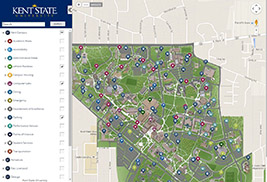
Kent State University has launched a new interactive map
for all of its campuses using CampusBird, a mapping and
media services product specifically geared toward higher
education institutions.The new map makes it easier to locate
campus buildings and parking lots.
Kent State University has launched a new interactive campus map for all campuses using CampusBird, a mapping and media services product specifically geared toward higher education institutions.
“Featuring a powerful map management system, the new map that is accessible via the Kent State website will feature 3-D building models, street view imagery and virtual tours,” says Sameer Jaleel, director of Web Presence with Kent State’s Division of Information Services. “This interface will allow for a better map and wayfinding experience for anyone on or visiting Kent State’s campuses.”
To make this happen, the Web Presence department had to compile photographs of each building on campus.
“We turned to crowdsourcing to make this happen. Web Presence reached out to IT Support personnel in every department and campus to accumulate images for all buildings, on which 3-D models were built,” Jaleel says.
This new map will benefit students, faculty and the community by giving them a more detailed look at Kent State’s campuses.
“If someone has a meeting in a campus building that they have never visited before, the new map will make it easy for them to locate the new building via their desktop or mobile device,” Jaleel says.
In addition, the map will make it easier for users to find parking lots located near campus buildings. Users can find recycling points and LEED-certified buildings on campus using the new map.
“Since its launch, we have added additional data points to the system including additional residence hall and accessibility details,” Jaleel says. “We are currently working on adding locations for bike racks, bus routes and stops, and recycling and sustainability.”
Jaleel says an upgrade that will bring user-interface and mobile-experience improvements to the map is planned before the end of the year.
To see Kent State’s interactive map, visit www.kent.edu/maps.
For more information about CampusBird Interactive Maps, visit http://campusbird.com.